 |
Northern Thailand
Chiang Mai
Chiang Rai
Kamphaeng Phet
Lampang
Lamphun
Mae Hong Son
Nan
Phayao
Phetchabun
Phichit
Phitsanulok
Phrae
Sukhothai
Tak
Uttaradit
---------------------------------
Northeast Thailand
Amnat Charoen
Buri Ram
Chaiyaphum
Kalasin
Khon Kaen
Loei
Maha Sarakham
Mukdahan
Nakhon Phanom
Nakhon Ratchasima
Nong Khai
Nong Bua Lamphu
Roi Et
Sakon Nakhon
Si Sa Ket
Surin
Udon Thani
Ubon Ratchathani
Yasothon
---------------------------------
Central Thailand
Ang Thong
Ayutthaya
Bangkok
Chachoengsao
Chai Nat
Kanchanaburi
Lopburi
Nakhon Nayok
Nakhon Pathom
Nakhon Sawan
Nonthaburi
Pathum Thani
Phetchaburi
Prachuapkhirikhan
Prachin Buri
Ratchaburi
Samut Prakan
Samut Songkhram
Samut Sakhon
Saraburi
Singburi
Suphan Buri
Uthai Thani
---------------------------------
Eastern Thailand
Chanthaburi
Chon Buri
Rayong
Sa Kaeo
Trat
---------------------------------
Southern Thailand
Chumphon
Krabi
Narathiwat
Nakhonsithammarat
Pattani
Phangnga
Phatthalung
Phuket
Ranong
Satun
Songkhla
Surat Thani
Trang
Yala
------------------------------
Southern Thailand
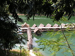
Southern Thailand is located on the Malay Peninsula, with an area around 70,713 km², bounded to the north by Kra Isthmus as the narrowest part of the peninsula. The western part has steeper coasts, while on the east side river plains dominate. เพียง 100 บาท ก็ลงโฆษณาได้ทั่วทั้งอินเตอร์เน็ตกับ บัมคิวThe largest river of the south is the Tapi in Surat Thani , which together with the Phum Duang in Surat Thani drains more than 8,000 km², more than 10% of the total area of Southern Thailand. Smaller rivers include the Pattani, Saiburi, Krabi and the Trang. ลงโฆษณากับบัมคิวราคาไม่แพง ได้ผลดีเยี่ยม The biggest lake of the south is the Songkhla lake (1,040 km² altogether), the largest artificial lake is the Chiao Lan (Ratchaprapha dam) with 165 km² within the Khao Sok national park in Surat Thani. Surat Than
i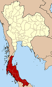
Ko Lao Liang Phi with the steep limestone hills present at most of the western coastRunning through the middle of the peninsula are several mountain chains, ลงโฆษณากับบัมคิวราคาไม่แพง ได้ผลดีเยี่ยม with the highest elevation at the 1835 m high Khao Luang in the Nakhon Si Thammarat Province. Ranging from the Kra Isthmus till the Phuket island is the Phuket chain,
which connects to the Tanao Si Mountain Range further north. Almost parallel to the Phuket chain but 100 km to the east is the Nakhon Si Thammarat or Banthat chain, which begins with the Samui island Ko Pha Ngan Ko Tao in Surat Thani and ends at the Malaysian เพียง 100 บาท ก็ลงโฆษณาได้ทั่วทั้งอินเตอร์เน็ตกับ บัมคิว border at the Ko Ta Ru Tao archipelago. The border to Malaysia is formed by the Sankalakhiri range, sometimes subdivided into the Pattani,
Taluban and Songkhla chain. At the border to Malaysia begins the Titiwangsa chain.
 |

The limestone of the western coast has been eroded into many steep singular hills. Those parts submerged by the rising sea after the last ice age now form the many islands, เพียง 100 บาท ก็ลงโฆษณาได้ทั่วทั้งอินเตอร์เน็ตกับ บัมคิว like the well known Phi Phi Islands. Also quite famous is the so-called James Bond Island in the Phang Nga Bay, which featured in the movie The Man with the Golden Gun.
 |
The Malay peninsula was settled since prehistoric times. เพียง 100 บาท ก็ลงโฆษณาได้ทั่วทั้งอินเตอร์
เน็ตกับ บัมคิว Archeological remains were found in
several caves, some used for dwellings, other as burial sites as well. The oldest remains were
found in Lang Rongrien cave dating 38,000 to 27,000 years before present, and in the
contemporary Moh Khiew cave.
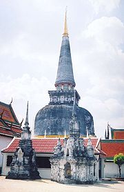
In the first millennium Chinese chronicles mention several coastal cities or city-states, เพียง 100 บาท ก็ลงโฆษณาได้ทั่วทั้งอินเตอร์เน็ตกับ บัมคิว however they don't give exact geographical location, so the identification of these cities with the later historical cities is difficult. The most important of these states were Langkasuka, usually considered a precursor of the Pattani kingdom; Tambralinga, probably the precursor of the Nakhon Si Thammarat kingdom, or P'an-p'an in Phunphin district Surat Thani, probably located at the Bandon Bay Tapi River. ลงโฆษณากับบัมคิวราคาไม่แพง ได้ผลดีเยี่ยม The cities were highly influenced by Indian culture, and have adopted Brahman or Buddhist religion. When Srivijaya in Chaiya extended its sphere of influence, those cities became tributary states of Srivijaya.The city Chaiya in Surat Thani Province contains several ruins from Srivijaya times, and was probably a regional capital of the kingdom. ลงโฆษณากับบัมคิวราคาไม่แพง ได้ผลดีเยี่ยม Some Thai historians even claim that it was the capital of the kingdom itself for some time, but this is generally disputed.
After Srivijaya lost its influence, Nakhon Si Thammarat became the dominant kingdom of the area.
ลงโฆษณากับบัมคิวราคาไม่แพง ได้ผลดีเยี่ยม During the rule of King Ramkhamhaeng the Great of Sukhothai, Thai influence first reached
Nakhon Si Thammarat. According to the Ramkhamhaeng inscription Nakhon was even a tributary
state of Sukhothai. During most of the later history Nakhon became a tributary of Ayutthaya.
The deep south belonged to the Malay sultanates of Pattani and Kedah, while the northernmost
part of the peninsula was under direct control of Bangkok. เพียง 100 บาท ก็ลงโฆษณาได้ทั่วทั้งอินเตอร์เน็ตกับ บัมคิว
During the thesaphiban reforms at the end of the 19th century, both Nakhon Si Thammarat as well as Pattani were finally incorporated into the central state. The area was subdivided into 5 monthon, which were installed to control the city states (mueang). ลงโฆษณากับบัมคิว สื่อโฆษณาแนวใหม่ กระจายทั่วทั้งอินเตอร์เน็ต Minor mueang were merged into larger ones, thus forming the present 14 provinces. With the Anglo-Siamese Treaty of 1909 the boundary to Malaysia was fixed. Kedah came under British control, while Pattani stayed with Siam.
 |